Tree Risk Assessment – Framework
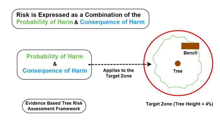
A straightforward, evidence-based tree risk assessment digital mapping platform that connects evidenced tree conditions with activity levels, and the probability and consequence of harm within a tree’s target zone.
Using this structured workflow, arboricultural surveyors and duty holders can make consistent, defensible safety decisions regarding trees to achieve and manage trees within a low-risk threshold.
Turning Tree Data into Actionable Insight
Mapscape delivers measurable commercial value for arboricultural consultants, tree owners and managers by integrating tree risk assessment within a powerful, easy-to-use GIS mapping platform, complete with optional 3D visualisation.
Surveyed trees appear as clear, colour-coded work priorities—from Very Low to Very High—providing an instant visual record and effortless data export, including automated Excel tree-risk reports.
An intuitive web-form interface ensures a consistent, evidence-based process that strengthens compliance and reduces liability. Practical and efficient, Mapscape converts complex site surveys into priority driven digital maps PDF reports, saving time, cutting costs and supporting confident arboricultural decisions.
How the Tree Risk Framework Works
1. Assessment – A qualified arboricultural surveyor inspects each tree, noting visible defects and site conditions.
2. Consideration – The level of human activity, property and infrastructure within the tree’s target zone is evaluated.
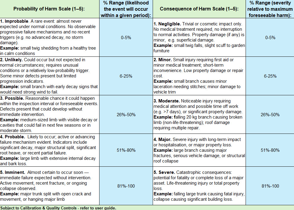
3. Selection – Appropriate Probability and Consequence of Harm scale values (1–5) are applied.
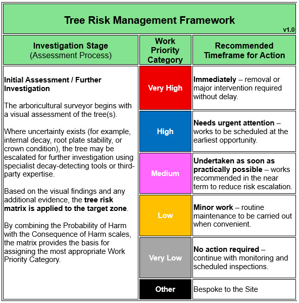
4. Outcome – Mapscape automatically calculates the Work Priority and recommended timeline for action.
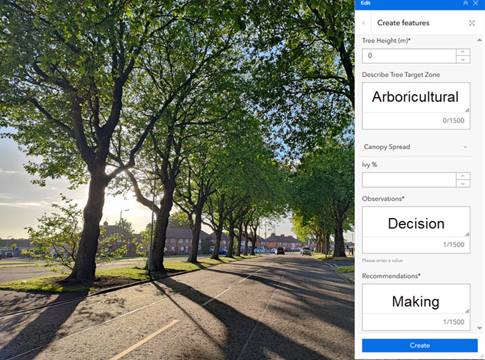
Mapscape enables users to capture photographs, measurements, tree-risk triggers and decision logic, producing a clear, objective and actionable report.
Clear. Flexible. Accountable.
Ease of Use
-
The Framework breaks down the tree risk assessment process into logical stages, where decisions are based on evidence, the specific context of each tree’s target zone, site specific conditions and the surrounding environmental benefits of trees.
-
The method reduces complexity, users can use a straightforward, transparent and flexible process that aids tree risk decision making.
Flexibility
- Probability and Consequence of Harm scores automatically determine a Works Priority from Very High to Very Low, though users can override this and record their reasoning.
-
The Objective of the Framework is to achieve and maintain a Low-risk value for surveyed trees.
-
The Framework supports managing tree risk for single trees at any scale of operations, without losing structure.
- The App also includes the ability to record groups of trees and hedges with a selection of digital and aerial imagery maps.
Incudes Digital Mapping
Mapscape Tree Risk Management App delivers the full capabilities of a modern GIS platform:
- GPS-based digital mapping of individual trees, groups, and hedges.
- Compatible with Ordnance Survey MasterMap (OSMM), National Tree Map, and high-resolution aerial imagery.
- Simple editing of tree locations and risk data.
- Instant generation of professional PDF site plans for planning or arboricultural management purposes.
Transparent Tree Risk Accounting
- Easily attach photos of observable tree defects from your mobile device; they are automatically compressed and included in the automated spreadsheet report.
- Clear accountability is ensured by recording who carried out each tree risk assessment and the associated action timeline.
- By logging re-inspections and work sign-offs, the app creates a transparent record of progress, enabling clients, stakeholders, and regulators to see completed work, upcoming tasks, and the reasoning behind every decision.
Fully Tracked
The Sign-off Works option provides tree owners and their agents with a straightforward way to track and confirm the completion of recommended tree works arising from a tree risk assessment.
The signing off process operates on a simple green and red editable traffic light system that is coloured coded to provide a quick reference visual progress check, that can be shared with sub-contractors.
Conclusion
The Mapscape Tree Risk Assessment Framework is working towards a robust, H&S audited, science based methodology that helps arboricultural professionals and duty-holders make informed, defensible decisions.
The Tree Risk Assessment Framework offers a clear, evidence-based workflow that links observable tree conditions within the tree’s target zone to appropriate work priorities and action timeframes. This empowers duty-holders to make consistent, proportionate decisions, with the objective of maintaining trees at a low level of risk.
Next Step
The basic version of the Tree Risk Framework is now available for commercial use. The advanced method, shown above, is still in development and is displayed here to gather feedback from interested parties including Risk Management agents and Health and Safety Evaluators.
Please contact our office with any questions or to express interest in User Acceptance Testing of the advanced method.
Reference Document:
*National Tree Safety Group. Common sense risk management of trees. 2nd Edition. PDF


